-
 en
en
-
 fr
fr
- Utilisez le Manuel de Style pour le montage correct.
- N'oubliez pas de retirer ce modèle une fois l'article correctement traduit.
« Back to Scenarios Team (en)
Contents |
Introduction
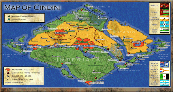
The Cindini map project was started during an internship in Tanzania (East Africa). One major aspect I always disliked about TTD was that the infrastructure of cities was terrible and that a city always was not much more then a big mess of streets and buildings put together. So I started making a Latin American/African based map and tried to make the cities feel more realistic and real. This is one of the major features in the Cindini map: most large Cities have a ring around it and they are connected with eachother by fast freeways and highways. The cities consist of different neighborhoods which have different appearances. You can find a downtown area where most shops and offices are located, slums, dense living areas with flats, rich villa neighborhoods, industrial areas, parks etc. Apart from the cities you will also find a high amount of detail in the landscape all over the map, some areas represent National Parks and reserves with mountain ranges, craters and vulcanoes and you will find beaches near the coast. The amount of detail is linked to the fictional lore behind this map we will tell about in the upcoming paragraphs.
The Cindini continent
The ethnic groups of the Cindini continent
The largest ethnic group on the Cindini continent is the Eurocindian population (48%) who originate from the early European settlers. They are of mostly Portuguese and Spanish descend and because of that are also sometimes referred to as “latin-cindians”. The second largest group is the multiracial population (25%) of a mixed European, African or Cindi-indian descent. They form the majority in Rutanio and South Ronia and are represented in all other countries on the continent as well. The fast majority of the Eurocindian and multiracial population is Roman Catholic.
The third largest group is the population of indigenous Cindinian descent (14%). Although most of this population was converted to Christianity, a large part of the Lewutu and Toneleda tribe (the two largest remaining tribes) still practice indigenous religions. The Ronian republic is the only country where the Cindi-indians form the majority. All over the continent the Christian cindi-indians celebrate “dia del creador” (day of the creator) every year with a large procession that climbs the Cerro el Creador in Dios Pueblo, the capitol city of the Ronian republic. Another large group of Cindians are from African descent (10%), mostly from slaves that were used on the plantations. The majority of the Afro-cindian population is Roman Catholic as well.
Beside the Eurocindian population there is a group that still refer themselves as European (6%), these are mainly the Dutch (Murica Isla), the British (Merlin Islands) and the French (around Prince-De-Paix) but also people from other European countries. There is also a relatively large group of (white) Africans from Boer descent. They started migrating to the continent when large amounts of Diamonds were found around Mia Bonanda where they played a crucial role in the independence of the Sinzia freestate (Freestate also refers to the Orange freestate, a Boer republic in South Africa). At the end of the apartheid a second wave of Boer immigrants from South Africa came to the Cindini continent. Later on they also migrated to the European islands (Murica and Merlin islands) and to South Ronia which has strong connections with the Sinzia freestate. Another small group of Boers migrated to the Highlands east of Äccerbol (Imperiata) in search of fertile farming land. Both the Europeans and Boers are mostly Christian protestants but also Roman Catholic or Atheist. You can find small Asian communities (2%) around the Metropolitan areas and at the Merlin Islands, mostly of Indian and Chinese descent.
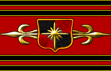
The Countries of Cindini
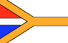
Impiriata
Capital city
Capitola
Goverment type
Federation
Head of state
President Caleiro
Population
1.725.327
Demographics
White 51% (Eurocindian 46%, French 2%, other European 2%, Others 1%), Multiracial 23%, Cindi-Indian 17% (Tonelada 9%, Lewutu 3%, Others 5%), Afro-cindian 6%, Asian 2%, Others 1%
Official languages
Cindi
Unofficial languages
French, English, Portuguese, Spanish, Local languages
Major exports
Mais, Rubber, fruit and wood
History
After independence from europe, this country once spanned the entire western and southern part of Cindini including the sinzia freestate, parts of Antia and Rutanio and the entire Ronian island group. In those times it was ruled by a violent dictator called Ricarneo who crowned himself “Emperor of Cindini". A lot of people were not happy with the current regime and this resulted in bloody civil wars in the eastern provinces and borderconflicts with Antia and Rutanio. After losing ground to Antia and Rutanio and the separation of the Sinzia freestate and the Ronian Island group the country felt into an economic crisis. This led to a long time of civil unrest and eventually to a coup which ended the reign of the dictator Ricarneo. A new democratic government was installed with Diatora, a former school teacher, as the first elected president. After the election Diatora managed to stop the violence and began an age of economic prosperity. Today Impiriata has a very strong economy however a very large part of the population still lives in poverty, especially in the mainland and in the hugh slums around the major cities. The country is split into six different self-governing provinces with the central goverment placed in Capitola. Impiriata has the largest population of Cindini continent, but most of them are gathered around the four major metropolitan areas, the mainland is sparsely populated.
Infrastructure
There are busy highways between the metropolitan areas and around the coastal areas. The infrastructure inside the city's is also well developed but the mainland however lacks a good road network.
Economy
Impiriata’s industries are gathered around the major cities, the coastline is breadbasket of the continent with a lot farming activity. They also celebrate an increasing number of tourists in the last couple of years visiting the cities and the National parks.
Environment
The largest part of Impiriata is covered with dense rainforest, in the north at the other side of the Chuach channel you can find arid lands and Rubero highlands in the outher Northwest.
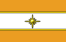
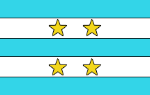
The Sinzia Freestate
Capital city
Mia Bonanda
Goverment type
republic
Head of state
president Roberto Valeiro
Population
400.014
Demogrhapics
White 66% (Eurocindian 38%, Boer 22%, European 4%, Others 2%), Multiracial 16%: Afro-cindian 11%, Cindi-Indian 6%, Others 1%
Official languages
Cindi
Unofficial languages
Afrikaans, English
Major exports
Diamonds, mais
History
Jacob Sinzia originating from a very poor family and was a worker in the diamond industry around the mining town Mia Bonanda during the regime of Ricarneo. While the population of the town lived in poverty, the money went mostly to the corrupt government in Capitola. Not long after the war broke out between Impiriata and Rutanio, Jacob started a rebellion in one of the major mines in the Mia Bonanda region. This spark started a chain reaction and, with the help of Antia which was also in war with Ricarneo, they managed to successfully separate themselves from Impiriata. In their strugle for liberation they got a lot of help from the South African mining companies operating in the area. South African mercenaries and volunteers played a major role during the war of liberation and the guirilla tactics they introduced were considered the most important winning factor. The boers in Sinzia are still heavely involved with Sinzia's economy and army, their growing numbers account already for 22% of the population. It's also due to the involvement of the Boers that they proclaimed themselves "Freestate" after the Orange freestate, a short-lived independant Boer republic. After the revolution the country rapidly grew into a massive economic power depending on the huge amount of Diamonds found in these lands. Today the Sinzia Freestate is one the richest and most prosperous countries on the Cindini continent with Mia Bonanda as it's capitol who grew from a minor mining town to a large metropolitan area and second largest City on the continent.
Infrastructure
The Freestate has an excellent infrastructure with freeways connected to Impiriata in the south and Antia in the east.
Economy
The Sinzia Freestate has the fastest growing economy on the continent. Mia Bonanda recently took over the position of business capital of Cindini for foreign investors from Capitola.
Environment
Most of the country consists of desert lands, with the exception of the northern coast were a handfull of Boer farmers settled down. The government recently successfully started a large irrigation project inside and around Mia Bonanda to make the lands more fertile.
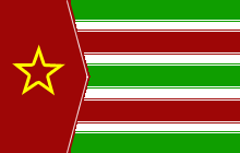
Rutanio
Capital city
Tilegro
Goverment type
Major natural resources
Iron Ore, Maize
History
The first country that successfully became independent from Europe. The lands first consisted of large patches of rain forests which were cut down and exported on a massive scale, making the country very rich and powerful. But this led to the total exploitation of most natural resources on the country and the country slowly turned into a remote desert. In search for new land and resources it made countless wars with Impiriata, which led to the conquest of the northern part of the Ronian island group. But due the the long wars and growing poverty in the mainland the population of this country also started to rebel which ended in a coup installing a communistic government. The new government did not bring the peace and wealth a lot of people hoped for which led to a migration to nearby countries, especially to Antia and the Sinzia Freestate. Today Rutanio is very poor and sparsely populated, a ruin of a once mighty nation.
Infrastructure
Though there are some few main roads leading to the capital, most of the countries infrastructure is in very bad shape.
Economy
The economy has gone downhill for a long time, though several years ago Iron Ore was found in the western provinces, which led to a slight increase in the country's economic position.
Environment
Almost the entire nation is covered in desert with the exception of North Ronia, the island in the south of the country.
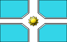
Antia
Capital
Antia
History
Antia was the latest colony on the mainland that (peacefully) gained independence from Europe, it started as just the Antioch mountain range and the swamp areas on the eastern side of the mountains. It was sparsely populated by local tribes and small European settlements. This changed when poverty became a serious problem in Rutanio, which led to a lot of farmers searching for more fertile land. Not long after their search the war broke out in the Sinzia Freestate, which led to people fleeing for the war. They took shelter in the Antioch Mountain range. Soon after the rebellion in the Freestate Antioch managed to train an army and also declared war on Impiriata which resulted in a gaining a relatively large part of Impiriata’s land. Today Antia is especially known for its beautiful nature and impressive mountains. Though Antia is still the official capital, the economic capitals are Teloria and San Elanzo on the coast and Lavito in the west.
Population
While at first Antia and the mountain range was the most populated region, the coastline is now the most populated area in the country.
Infrastructure
The infrastructure in Antia is reasonably good, recently the country built its first impressive freeway (thanks to investors from the Sinzia Freestate) from Mia Bonanda to San Elanzo which is now one of the continents major export harbors.
Economy
The economy is prospering in Antia, especially tourism to one of the two national parks in the country is making a lot of money in recent years. This led to the booming of the once small mountain town of Lavito.
Major natural resources
Maize
Environment
The western part of the country consists of desert while the eastern part is a swamp area, the two areas are split by a large mountain range.
Murica Island
Capital
Johanstad
History
This is the place were the first European explorer set foot on the Cindini continent. Since that time multiple European countries have occupied this island. The Europeans used this island as a major slave port from where they shipped the slaves to the main continent. Even though in 1800 all slaves gained freedom this island stays under European control until today. Since 1800 no war has been fought on this island and it grew out into a very wealthy and peaceful island with little problems.
Population
The island is very populated, especially around the two big cities. This island has the highest percentage of Europeans in all Cindini and most of the large companies are in the hands of European investors.
Infrastructure
The infrastructure on Murica Island is excellent and probably the best on the entire continent
Economy
While the island also produces maize and fruit, the main economic resource is tourism. Murica is one of the top tourist destinations on the continent thanks to the stability of the country, the world class beaches and some of the best diving spots in the world.
Major natural resources
Maize and fruit
Environment
In general the island is green and lush while on the west side there is also a small stroke of desert.
Les Dianos
Capital
Zidena
History
Les Dianos are a group of four islands: Dia Porto, Dia Puena, Dia Tako and Dia Nupla. Its capital, Zidena, was, for a long time, one of the most prominent European ports on the continent and the islands were one of the latest to gain independence peacefully. In general the islands have always been very peaceful and few conflicts were ever recorded. While officially being neutral during the war between Antia and Imperiata the islands were believed to support Antia both financial and military.
Population
Like Antia, Les Dianos has also known a great migration of people from Rutanio during the war period making it a reasonable densely populated area these days.
Infrastructure
The infrastructure on the island has always been relatively good compared to the mainland. Since the construction of the Dinota bridge in 1979 all the islands have been connected to each other and in 1986 the country was connected to the mainland by the huge Capota bridge.
Economy
The island state depends on its Rubber plantations and farms but also has been an interesting destination for tourist.
Major natural resources
Maize and Rubber
Environment
The country consists of wetlands and farmland with rock formations.
South Ronia
Capital
History
Population
Infrastructure
Economy
Major natural resources
Environment
The Ronian Republic
Capital
History
Population
Infrastructure
Economy
Major natural resources
Environment
The Merlin Islands
Capital
History
Population
Infrastructure
Economy
Major natural resources
Environment
Project Organization
Project Team
- Whopper - project leader/owner
- Sleepie - volunteer
This article aims to organize the work on Whopper's unfinished Cindini map (TT-Forums Thread / Old TT-Forums Thread). More details will follow soon.
Design Rules
Because multiple persons are working on the map we have several "design rules" to ensure the map stays on a high quality.
Road types
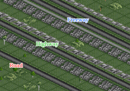
Because openTTD doesn't include different types of road yet we are representing the importance of a road in other ways, in general we have the following three types of roads:
Regular road
The regular road is just the normal road that can be used anywhere, there are hardly any restrictions on how to make use of this type of road as long as they make sense. When building a road from one place to another bear in mind that they are not necessarily straight, so try to shape the road by its enviroment, instead of going through or over mountains or over cliffs try to let them go around those. Also try to make only 1 level of elevation behind eachother so instead of going straight to the top they will sway slowly up. When using bridges with the normal road types try to use cheap bridges instead of expensive ones. While playing on the map these curves and elevations will make a normal road less attractive then a highway or freeway.
Highway
Highways are important roads between cities or inside cities. The highway is a single road that is elevated 1 level higher than its surrounding. Inside cities you should try to not directly build buildings next to the highway but leave 1 block of space. Try to make the highway go as straight as possible without using too much elevation. Highways go through mountains or over cliffs instead of swaying around them. You can directly connect any regular road to the Highway but try to avoid to connect too many roads to a highway behind eachother.
Freeway
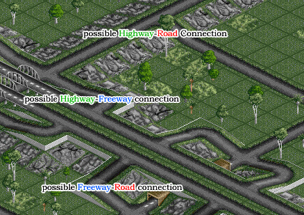
The freeways are the most important roads mostly connecting metropolises or large cities together or they are used in a ring around a metropolis. The freeway is a double road elevated 2 or more levels higher than its surrounding with both roads built on a slope making it normally impossible for any road to connect with it. To connect a freeway with a road, highway and other freeways you should use four connections from the specific road to the freeway like on the picture below. Freeways go as straight as possible, and have as little elevation as possible. Instead of changing the freeway to the terrain, change the terrain to suit the freeway. Inside large cities and metropolises sometimes double roads are used, but these are not freeways, freeways are always elevated and have special "ramps" which connect them to normal roads and highways.
Creating a city
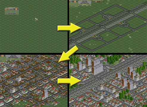
Step1
Make a "global plan" for the city by placing the important roads (see the above picture), you can also place canals or roads on places that you plan to hold free from any buildings (like a park or the space beside a highway). In this case I built a single highway with some mayor side roads.
Step2
Actually place the city and expand it to the size that you find suitable.
Step3
Is the most time consuming step and can take up to several hours for metropolises. You have to clean up the city by deleting useless roads or illogical roads and expand/delete to get certain types of buildings into certain areas. For instance in this picture I tried to make some squares with high buildings around it while the rest of the city consist of luxury low level buildings. After making sure the buildings and roads are fixed I usually fill up the empty areas with trees and hills.
Creating a mountain range
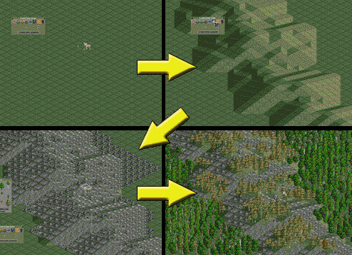
Step1
Make the shape of the mountain with the land generation tool.
Step2
Cover the elevated area with rocky ground.
Step3
Add trees: place lushy green trees around the mountains on the normal surface while placing the more sober trees on the mountain itself, placing them on plateaus and on some of the slopes.
Project status
This section is about Who is working on What and When. The idea is to split the map in several (virtual) regions. Each region represents a sub-project of the whole thing. These sub-projects will be assigned to one (max. three) volunteers who will work on this until it's finished. The sub-projects will be marked with signs on the map. Additional signs that provide information about who is working on that project, what is the state (Unclaimed|Planning|WorkInProgress(%)|Finished) of it and so on might be also useful. Besides this further (detailed) information should be documented at the wiki. So we will get a 'changelog' of the progress. Discussing things could be done using several ways using the wiki, the forum, email or instant messaging, whatever is appropriate. Because it's not possible to split the map physically some kind of project schedule is necessary to organize who can work when.
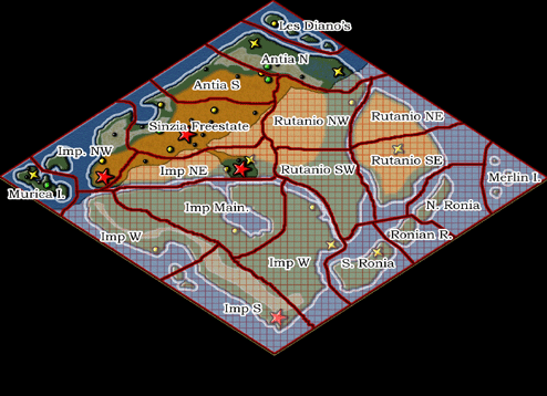
| Project (regions) | Assigned To: | State | Last Update | Remarks |
|---|---|---|---|---|
| Les Dianos | Whopper | Finished | 2007-03-24 | Finished part |
| Antia North | Whopper | Finished | 2007-03-24 | Finished part |
| Antia South | Whopper | Finished | 2007-03-24 | Finished part |
| Impiriata Northwest | Whopper | Finished | 2007-03-24 | Finished part |
| Impiriata NorthEast | Whopper | Finished | 2007-03-24 | Finished part |
| Impiriata East | Whopper | Finished | 2007-03-24 | Finished part |
| Impiriata Mainland | Sleepie, Whopper | Finished | 2007-03-24 | Finished part |
| Impiriata West | Sleepie, Whopper | Finished | 2007-03-24 | Finished part |
| Impiriata South | Sleepie, Whopper | Finished | 2007-03-24 | Finished part |
| Murica Island | Whopper | Finished | 2007-03-24 | Finished part |
| Rutanio NorthWest | Whopper | Finished | 2007-03-24 | Finished part |
| Rutanio NorthEast | Whopper | Finished | 2007-03-24 | Finished part |
| Rutanio SouthWest | Whopper | Finished | 2007-03-24 | Finished part |
| North Ronia | Sleepie, Whopper | Finished | 2007-03-24 | Finished part |
| Ronian Republic | Sleepie, Whopper | Finished | 2007-03-24 | Finished part |
| South Ronia | Sleepie, Whopper | Finished | 2007-03-24 | Finished part |
| Rutanio SouthEast | Whopper | Finished | 2007-03-24 | Finished part |
| The Merlin Islands | Whopper | Finished | 2007-03-24 | Finished part |
Comments & Suggestions
If you have any comments or suggestions to this project just add it here (please don't forget to sign your comments).

