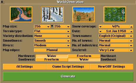
The New Game menu, on the top left of the main menu, lets you start a new game using a randomly generated map, while the Play Heightmap button lets you start a newgame with a map generated from a Heightmap.
Contents |
Options
The following list goes through each option from top to bottom, going through the left column before the right.
Climate
The top row selects the Climate to use. From left to right there are Temperate, Sub-arctic, Sub-tropical, and Toyland. Note that Sub-arctic and Sub-tropical have special rules, and Toyland has a limited vehicle selection
Map Size
This controls how big the map will be. The smallest size is 64 tiles while the biggest is 4096. For single-player, 512x512 will give you plenty of room.
Terrain type
This controls the height of hills and mountains by setting the maximum height of the map. When Custom height is selected you can set this height manually, by default it is 30 and can be set anywhere between 1 and 255.
When this option is set to any other type, the map height limit is scaled according to the size of the shortest map edge. For example, on a map where one or both sides are 64 large, the height limit even when Alpinist is selected is set to 12, while if both sides of your map are at least 4096 large, the limit is set to 87.
This is to prevent a single mountain from completely covering the map in slopes on smaller maps, as OpenTTD cannot support a slope steeper than 1 to 1.
The full list of height limits for each setting and map size is as follows.
| Shortest Edge (tiles) | |||||||
|---|---|---|---|---|---|---|---|
| Preset | 64 | 128 | 256 | 512 | 1024 | 2048 | 4096 |
| Very flat | 3 | 3 | 3 | 3 | 4 | 5 | 7 |
| Flat | 5 | 7 | 8 | 9 | 14 | 19 | 31 |
| Hilly | 8 | 9 | 10 | 15 | 23 | 37 | 61 |
| Mountainous | 10 | 11 | 17 | 19 | 49 | 63 | 73 |
| Alpinist | 12 | 19 | 25 | 31 | 67 | 75 | 87 |
Variety Distribution
This controls whether the map contains both mountains and flat areas. The higher the variety, the more differences in elevation between mountainous and flat areas.
Smoothness
This controls the shape and number of hills. Smooth landscapes have fewer, wider hills; while rough landscapes have more, smaller hills.
Rivers
This controls how many rivers to generate.
Snow coverage
This is only available with the Sub-Arctic Climate, and controls the approximate percentage of the map which is covered in snow. Snow, besides looking pretty, also affects industry generation and town growth requirements. Sea level and coast tiles never have snow.
The map generator accomplishes this by calculating a height above which is located approximately the percentage of tiles you chose. For example, if you chose a snow coverage of 10%, the map generate will choose a snow line height such that approximately 10% of the tiles on the map is located above it, and then everything above this height is filled in with snow, including land raised later through terraforming. However, since this calculation is run only when the map is generated for the first time, the snow height will not change in response to you terraforming the map.
Date
This is the starting date where your game starts. The default game starts in 1950. The year controls the availability of vehicles, infrastructure, among other things.
No. of Towns
This controls how many towns are generated. It will depend on the size of the map.
The options are Very Low, Low, Normal, High, and Custom. When Custom is selected, you can set the number of towns which are generated to anywhere between 1 and 5000.
No. of Industries
This is how many industries are on the map. It will also depend on the size of the map.
The options are User funded, Minimal, Very Low, Low, Normal, High, Custom. When User funded is selected, no industries are generated and you will have to fund industries yourself. When Minimal is selected only one of each industry is generated. When Custom is selected, you can set the number of industries which are generated to anywhere between 1 and 9999
For the Very low to High values, lower values are more useful at larger maps, while higher values are more useful at smaller maps.
Sea Level
This controls the percentage of the map which is ocean. When Custom is selected, you can set this percentage anywhere between 1% and 90%.
Map Edges
This controls whether the edges of the map are at sea level or land can be generated up to the edge. If you select Random, then the map generator will randomly decide, for each edge, whether to generate land up to it. If you select Manual, then you can use the four buttons below to select for each edge whether the whole edge will be water (with Water) or the edge will be both water and land (Freeform).
Closing Remarks
The AI settings, Game Script Settings and NewGRF Settings buttons simply show the same settings menus that you can access on the main menu, such that you don't need to exit the new game menu and lose all your progress to change other settings.
Now that you have set all your settings, press Generate to get started! Once the map has been created you will be taken to the Game interface.


